Day 07 was our day to leave Bangor, visit Acadia National Park, and then start making our way towards Boston (photos 1-2). Jacob had planned our trip to the Park, and it did not disappoint.
We drove over a big bridge from Bangor to Brewer, near where we had visited the waterfront park the day before, and headed for Bar Harbour. We eventually crossed over another bridge to Maine Desert Island and the tide was low (photos 3-12). We drove around Bar Harbor, which had a resort-town feel. It was very crowded for a Friday, with no parking anywhere in the downtown area. We ate lunch at a nice seafood restaurant on the water, just outside Bar Harbor, with great lobster rolls and lobster mac and cheese (photos 13-16).
We drove into Acadia National Park and made a tactical error — we didn’t stop at the Info Centre to get a map, since we had GPS. The park has a road that does a loop around it, and not a lot of good signage. Essentially, although we didn’t know it, you can do a clockwise loop only — we assumed we could do either way as the opening section is bi-directional. As we drove along, there were lookouts with a bit of parking, all of which were filled. We stopped at an area where you could walk down to Jordan Pond, but I ended up doing about a 30-minute circle in the three adjacent parking lots while Andrea and Jacob walked down (photos 17-44). The photos show a beautiful lake surrounded by hills. There is no swimming allowed as it is a local source of drinking water.
We drove on and saw the road divide into the uni-directional route (the opposite way), and ended up going out the South West Gate. We saw a bit of the island coast and then re-entered the park, retracing our route to Cadillac Mountain (photos 45-50). We had debated going up the Mountain or not, there was a separate charge for it over the park pass, you had to schedule it, etc. But what the heck, we pulled up to the checkpoint and said, “Soooo, what’s the deal, how do we do this?” We had to buy our spot online, which was only about 15 minutes from then, so we pulled over on the main road to do that, then back into the short line and up the mountain. It was the absolute best part of the visit, and I can’t believe we almost didn’t do it.
There were amazing views on the way up and at the top. The summit had nice walkways and viewing areas, natural-looking, a big open area that wasn’t too crowded (although the parking lots were full). We visited the gift shop although that was primarily to get some cold water — it was a warm day, particularly on top of the mountain with no shade anywhere. The mountain top itself is pretty rocky, and we could see lots of boats, islands and ships (photos 51-159).
We had picked up a map at the gatehouse to the Mountain route, and could now see the uni-directional loop and where it started. As much as we would have enjoyed doing the loop too, we didn’t even do the Mountain part until 3:00 p.m. and it was now almost 4:30 p.m. with a long drive ahead of us still. We weren’t sure if we were missing much though as we could see all of the island from up top. Still, it would have been nice. But time waits for no tourist! Off we went, driving the same route to get off the island and to see it at high tide now (photos 160-166).
After that, we headed down the coast of Maine. We had hoped that a nice leisurely drive down the coast would present almost one continuous view looking out over the ocean. Of course not. That land is too valuable for mere roads; almost all of it is has houses and buildings on it, with the view from the road often limited to trees or gaps between trees. We saw some larger interesting bridges and a few beach / marine areas, and a nice sunset, but most of it was uneventful (photos 167-181). We had dinner in Rockland at a McDonald’s, and Andrea had booked us a Fairview hotel in Brunswick. The hotels in that area (Portland) were very expensive (and fancy), but the main thing I noticed was that it was almost pitch black on the roads getting to the hotel itself — I could barely FIND the turns.
But we made it. We drove 354 km for the day, and took a ton of photos — 574 in total, curated down to 181, including 1 video. A small Easter egg in the video is that as Andrea pans around, she captures the bird that I’m taking pictures of in burst mode. Another great day, planned by Jacob. I think we’ll keep him around.
Day 06 turned out to be a very dreary and dull overcast/wet day. Jacob wasn’t feeling very well, so we opted for a quiet day around the hotel and Bangor (photos 1-2). We had a good breakfast at the hotel again and played games.
I went out on an errand to look for some pharmacy stuff for Jacob at a nearby mall. Like most malls in North America, it has been decimated. I went to Dick’s Sporting Goods on a separate errand. I normally have a small shoulder bag that I carry with me, almost a man purse, and the last one I got was from Mountain Equipment Co-op. They still sell the model, which lasted me quite some time, but I thought if I could find something similar while on our trip, I’d grab it and have a souvenir too. Dick’s had bags in about 8 different places in the store, none of them like what I was looking for…I would have considered a more traditional messenger bag too, as I seem to have lost mine (I might have given it away without realizing it at one point), but nada. I wandered through the mall anyway looking for any bag store or sports store, but nope, not a one. Nor was there anything resembling a pharmacy although the map of the mall showed lots of POSSIBLE stores, none of which were where they were supposed to be. Or at least, not anymore. I gave up on the bag and stopped at a grocery for Jacob’s stuff.
We went to a local Applebee’s for lunch, which was surprisingly good, and surprisingly busy as we went after the lunchtime “rush”, early afternoon, and they were still busy.
We were looking for an indoor activity, and had a recommendation from a website to try the Galen Cole Family Land Transportation Museum. It had cars, trains, bikes, snowmobiles, snow ploughs, fire trucks, farm equipment, etc. It wasn’t very busy, and as one big garage/warehouse, volunteers were able to provide info as needed. They had a small scavenger hunt you could do while touring the museum where you “spot” various wheels and mark which display they were from on a checklist.
Much of the museum’s material had been donated. When it started, they announced in the paper they were creating the museum and asked if people had items to give. Lots of people did — including farm equipment, for example, that had been used by grandparents or great-grandparents and then left to sit in barns or fields for 50 years before being restored by a descendant and then donated. Similarly, the museum also included a full rural “train station” from the area. The railway company had called the creator, Galen Cole, and said, “Hey, we’re getting rid of this train station, do you want it?”. Cole did, and he got it for $1 on the condition that they come and take it from the land. Which he did, putting it in the museum. Until a few years later when the company sold off the land, which Cole bought, including four more stations with it. The train station in the museum was pretty cool, including the post office portion. A true slice of history to walk into, from an adventurous time when rail travel was more fundamental to cities and small towns.
One of the volunteers, an older gentleman in his 70s at least, although I suspect more like his 80s, took to chatting near the end. I mentioned our plan to go on down to Boston. He told me how he went to one of the fast food chain’s training schools in Southern Maine when he was a younger man, and some of them went into Boston two or three times. His conclusion? “It wasn’t for me.” He had no interest in a big city, and he hinted that he basically had spent his entire life in the Bangor area with no interest to go anywhere else, and certainly NOT to anything resembling a big city. It would be nice to just sit and chat with him for a decade or so. But, alas, the museum was closing. We visited the Vietnam Memorial outside with a helicopter (Huey, UH-1), and the WWII memorial (with jeep and tank), plus a covered bridge. We added to our photo collection (photos 3-39).
We still had a bit of daylight, even if it was rainy, so we decided to drive around downtown Bangor. Saw a mural or two, lots of churches, a Masonic lodge, etc. Then across the bridges to a waterfront park, for views of Bangor’s “skyline” (photos 40-63).
We stopped near the hotel to check out a store called BAM — Books-A-Million. It is a large Chapters/Indigo-like store, very modern but welcoming, with a decent magazine section, lots of mainstream adult and kids books on the main floor with genre stuff on the second, along with games, puzzles, and anime out the wazoo. We picked up a game or two, and a puzzle. I could spend a week there. Or just move in. A wonderful store.
As we had already ticked off Jacob’s desire for Pizza Hut and Applebees, it was time to fulfill Andrea’s dream — Olive Garden for dinner! We played trivia while we noshed, and Jacob was more in heaven than Andrea — the menu had a WHOLE section devoted to Alfredo sauce.
It was a light day for driving, with only 23 km logged. On photos, we only took 84 and I curated that down only slightly to 64.
We awoke in Bangor and our plan for the day was to visit Baxter State Park (photos 1-2). Jacob had taken the lead in planning our visit to Maine, and he really wanted to see the mountains in the park including Katahdin.
We had a really good breakfast at the hotel, with a nice setup overall and not too crazy busy. We drove to the park, near Millinocket, about 90 minutes north of Bangor itself (photos 3-9). We entered at Togue Pond Gate, after stopping at the info centre to plan the day. Between getting out of the hotel and up the highway, and then through the gate (photo 10), it was almost lunch time. We stopped at Abol Pond for a picnic and to enjoy the scenery after the car ride. It is part of the Appalachian Trail, with a cute bridge, some frogs and some salamander-like fauna in the water. Very peaceful (photos 11-32).
We drove on and stopped at Stump Pond (photos 33-43). It was our first view of Katahdin Mountain, the highest peak in Maine at 5269 feet. There’s no road to the top, so if you want to get there, you have to climb. Not on our schedule for the day, fortunately. There were some logs in the pond, surrounded by swamp, and on a hot day, I assumed there would be turtles all along the logs. I never saw any all day. I don’t know if they don’t have them, or if I was just not finding them.
We continued to drive through the park, catching glimpses of the mountains as we went (photos 44-59). We stopped at an area called the Slide Dam, which seemed oddly named as I saw neither a slide nor a dam anywhere in the area. There were some people wading in the slow rapids, and there was a nice mountain view, along with a small set of falls/creek merging with the river (photos 60-75). Some more driving produced more peek-a-boo shots of the mountain (photos 76-77) and then it was time for…Ledge Falls. It’s a large natural splash pad, with lots of people swimming and drifting down the rapids. A local adventure camp had about 10-12 young men out for the day and were swimming plus teaching them about nature. The spot had a great layout, a mix of fast and slow rapids, nothing too scary for kids, and a nice set of small falls at the top. The swimming was topped off by a nice view of the mountain view above (photos 78-97).
This was the farthest part of our trip through the park, so we turned around and headed back down the Eastern edge of the park that we came up. We passed Foster Field which had a good view of the mountains ahead and the ones now behind us too (photos 98-108). Kidney Pond was shown on the map, and we thought it might be a good scenic pond to visit. We had no real expectations for the diversion off the main road, we had just flagged it for follow-up on our way back. The surprise was that as we crossed a small bridge over the same river we saw at Slide Dam and Ledge Falls, the river delta opened up and we had our best views of the mountain of the whole trip (photos 109-111). Spectacular. We never made it to the pond, the trail was too long for our schedule, so we tried for Daicey Pond and campground. It had a canoe launch, but not much else to see. Again, on the way back, there was an open area with a great view of other mountains in the chain (photos 112-124).
We left the park and headed back out the highway. As we drove, Jacob mentioned that there was this other pond he really wanted to try to reach. It had been in a lot of the photos he saw of the mountain, as if it was the perfect spot for taking photos. It was called Compass Pond, but it wasn’t part of the Park, it was off the highway to the left somewhere. And so began the adventure. The road to get closer to the pond was brutal. It was a wide dirt road, with huge potholes and rocks. We were in a cross-over SUV and it was a pretty rough ride. I think it would have been jarring in a 4×4, to be honest. It finally merged with this huge wide gravel road, wide enough for four lanes in fact, with some grading issues in places, but easily drivable. We drove along for a bit, and there were no roads going to Compass Pond. We could see the pond, but no specific place to park, nada. How did people take the photos? I wasn’t sure, but well, I could improvise. I turned around and drove slowly along the road until I found a small trail going towards the pond. It wasn’t far, maybe 125 feet or so through the woods. We parked, hiked, snapped some pics, fed all the local bugs, and then raced back to the car. But we got the photos (photos 125-129).
As we continued back, we passed through some cottage country lakes (photo 130) and then we decided we would take a detour north to a supposedly great scenic lookout of Katahdin off the highway. Bear in mind that the mountain is about 45 minutes driving time from the highway, and you can barely see it from the highway (photos 130-134). It was a nice view of the estuary and river, with faint mountains in the distance, but it was time to go back. We debated a bunch of options for where we were going to eat along the way, but we just pressed on and finally went to Wendy’s near our hotel.
It was a great day for weather, with perfect viewing and not deadly hot for us. Jacob planned a great outing for us, among the best of the trip. It was a long day for driving distance, 384 km, although up until the final drive on the highway, it didn’t seem that bad for most of it. We had lots of great sights to see, with 332 photos taken and curated down to 135.
If today is Tuesday, this must be Mount Washington! (photos 1-2)
Okay, well, actually it was Gorham, to be precise. We were up early, had a decent but crowded breakfast at the hotel, packed up and checked out, watched the low-hanging clouds near the hotel for about half a second, and then blitzed for Mount Washington (photos 3-7). We had booked our tickets for the Cog Railway up the mountain that was departing at 10:00 a.m. We planned to arrive about 15 minutes early, and left in good time.
Except the GPS had other ideas. It took what looked like a good shortcut to shave some time off the main highway, sort of a wobbly hypotenuse on a triangle that would have otherwise taken us North and West of our destination. Except the map decided about halfway along to tell me to take a turn that didn’t exist, and then when I turned around and went back to look, there WAS a road — one that was gated and clearly CLOSED. It did not look like anything a GPS should have been sending me towards though, more like a commercial quarry or something. Anyway. Frustrating, and worrisome, but I knew generally what it was TRYING to do before it did that, so I ignored the GPS for a bit, continued along its original suggestion (the hypotenuse) and then finally it caught up when we met the west side of the triangle. Very stressful and ate up valuable time.
We made it to the railway base station, got to the “station” area, and there was a line. Jacob and I went to the train while Andrea waited in line. I’d like to say we made it under the wire, but we really didn’t. They held back 3-4 minutes just for us, and for Andrea to get through the line-up. We thought we could just get right on, but she had to go back and wait. All good in the end, but not a fun start to our day. We shook it off, cuz it was ALL ABOARD!
For our ascent, our conductor’s name was Hannah who taught us that the railway runs bio-diesel engines and it is a “cog” railway as there are cogs (like on a bicycle) on a large spindle that turns and “locks” into the set of holes in the track so that it can “bite” and pull the engine along. Interestingly, the engine basically pushes the cars up and slowly lets the cars come down, but is not attached to them. It’s not the “pull” situation you normally expect with trains. There were really good views of Mount Washington and ravines, although nothing looked level due to the angle of the track and hence the railcar. Some sections are very steep. The railway has an interesting history, having been built originally in 1869. It is a 45-minute ascent, very slow, with the steepest part at the top called Jacob’s Ladder. As we went up, we saw hikers, and then nearing the top, we could see drivers on the auto-route. There is NO way I would have enjoyed that driving experience, now having seen the top, so I am VERY glad we didn’t do it. (The ascent is from photos 8-61). On the way up, they had us try “standing” twice. The first time was early in the ascent, not super steep, and it was interesting. You could definitely feel the work you had to do to maintain your standing position, but it wasn’t hard. When we reached Jacob’s Ladder, the steepest portion at 38 degrees incline, we tried to stand again — it was brutal. You COULD do it, but you couldn’t hold it comfortably for long.
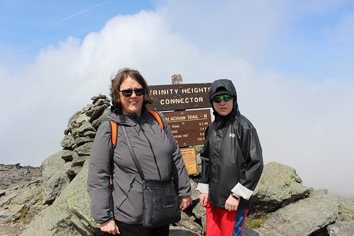
At the end of the ascent, you get to spend one hour on the summit (photos 62-111). The summit is 6288 feet, the highest in New England. It was very cloudy with the clouds moving quite quickly. It was somewhat cold, but not super busy, which surprised me until I reminded myself it WAS a Tuesday, not a weekend. I guess only the real tourists are out on Tuesdays. We posed for photos, mailed some postcards, and took lots of photos. We could even see the base of the Auto-Route (where the gift shop was) from the day before, once some of the clouds cleared. It was pretty wispy for most of our hour, but in the last 5-10 minutes, the sun was out a bit more.
We started our 45-minute descent, but as a digression, I was a bit confused by their model — the railcar on the way up was far from full, somewhere between perhaps 40-60%, depending on how you calculated “full”, and a couple of the other railcars went up empty with some others coming back down empty. They have side spurs so they could pull off to pass so it wasn’t that if one went, they all had to go. But they seemed to run all of the cars at once, regardless of the immediate demand, and it is one car per engine. Equally, they told us to come back down with the exact car we went up in…yet others joined our group without any sort of “reconciliation” process for them to know that the person was now on this car instead of the other one, and one group even seemed to leave some friends behind to catch the next one. In short, they appeared to run it like a railway with ticket takers, counting, check-ins for each “car”, and actual assigned times, but lots of people seemed to be using it more like a subway system, catching whichever train was available. They did mention that you COULD also do the train one-way — hike up and ride down or ride up and hike down — which could throw off their numbers sometimes. The one young narrator mentioned that there had been a really cold snap back in June when a whole bunch of hikers got caught by cold nasty weather near the top — so they cancelled their hiking plans to descend and all piled into the railcar. Which was already full, and so they ended up sitting / standing in the aisles. Which NONE of the other passengers were very happy about, apparently. It just seemed like a very strange business model — why send empty cars so often and why insist on matching tickets? I wondered if maybe it was a volume thing…if it was near capacity, everyone had to treat it like a train; if it was as light as it was our day, people could treat it like a subway.
Anyway, digression aside, it is an equally slow descent (45 minutes at 5 miles per hour). This is when we learned about the railcar not actually being attached to the engine, so if the engine suddenly had a problem, our car itself needed its own brakes and steering options, WITH a conductor (named Jacob!) who looked like he was 14 being responsible for our safety in the event of a runaway. It was not very comforting. 🙂 What WAS comforting for our return was that the benches in the railcar were convertible. They start off facing uphill, and then can be flipped so they face downhill. We had padding for the downhill portion, which was much more comfortable than the ascent, and we had no need to test their safety plans. We also learned some stories about past railway staff in history using the tracks like a railway luge which didn’t go over very well with the safety boards, which banned it and made it a criminal offence. And we learned something interesting for the weather even this year — they had more snow in JUNE than they did in February. Not sorry I missed that experience. From the photos, you can also see that as we descended, we went from almost non-existent vegetation (except growing on rocks) into small shrubs and then a bit of distance to get into actual full trees. The lichen at the top is very short and reflects a lot of light — hence it appears white from a distance, and hence the name White Mountains. (The descent and base are seen in photos 112-161).
We had a blast on the train and the summit. Hence struggling to curate the gallery below 150 photos. There was a lot to see!
We knew our final destination of the day was Bangor, Maine, and if you asked the GPS to find you a route, it would have sent you back North. So we went South, of course. We headed for North Conway, past the Mount Washington Resort (hotel) which is huge and iconic — and across the road from the Bretton Woods hotels that were the site of the meetings that created the World Bank and the IMF (and why they are called the Bretton Woods institutions). We cruised along until lunch, enjoying more of New Hampshire and the White Mountains, and then ate at a Dairy Queen before continuing on to North Conway. We crossed the border into Maine and enjoyed a leisurely drive through what looked like cottage-country with lots of lakes and rivers (photos 162-170 pre-Maine and 171-175 for early Maine).
The only real downside to the drive was the dang GPS. It kept giving us really weird routes…2 km down a road, and then a turn; another 1 km and then a turn back; then go straight for 2 km and I’d be back on the same highway. It took us on perhaps the “fastest” route but with no real sense of purpose. Some of the twists and turns looked longer than if we’d just taken the main route. I eventually had to call a halt to the twists and turns as I couldn’t enjoy the trip if, every five seconds, I had to check where we were. We instead pushed straight to the major interstate and headed North.
It was a long day at that point, after being up early and three hours on the Mountain, so we were focused on getting to Bangor where we had a hotel room for the night. We had been having this on-again, off-again conversation if we were trying to definitely see every state capital or not, and if any of the three of us cared enough to push for it as opposed to all three of us thinking the same thing i.e., “sure, why not, unless there was a reason not to at the time”. As we got closer to Augusta, we found a reason.
We could see a storm coming from a long way off. Very dark, very threatening skies. About 4 interchanges before Augusta, the storm hit. It was still daytime, so the roads were well-lit, but I had no real interest in finding my way around an unfamiliar state capital in the pouring rain to maybe see a building through the downpour. We skipped it and stayed on the highway. I had good traction and visibility; the driving was all fine, so I just kept going. I didn’t see many people pulling off, but the storm lasted a good 45 minutes of very hard pounding rain, lightning bolts in the distance, and lots of thunder. It stopped for about 30 minutes and then came back again for another 15-20 minutes. I saw there had been an accident on the other side; it looked like a bad wreck, but otherwise, no sign of anything. Just a strong storm (photos 176-181).
We arrived at the Comfort Inn at Bangor and found out that we should be considered “lucky” to have a room as tourists, as there was a big concert in town that night. Godsmack and Staind. Of course, I could obviously see the desire and why there would be such high demand (I have no idea who either band are or how that would fill every hotel in Bangor, but apparently the storm had closed a bunch of airports on the East Coast so some people were stranded too). Anyway, we checked in and settled for a little bit before heading out for dinner. I had mentioned Andrea’s excitement earlier at seeing an Olive Garden in Vermont? Well, we didn’t go there. But we did go to a functioning Pizza Hut. Jacob really likes Pizza Hut, but the one closest to us shut down as an in-person eatery; it’s just take-out now. So, we found the Pizza Hut and went for dinner with a whopping two other tables active. Admittedly we were a bit later than the Pizza Hut crowd would normally eat, closer to 8:00 p.m. than 5:00 p.m., but the waitress mentioned that lots of people coming in tell her the same thing about Pizza Huts in their hometowns all along the Eastern coast, down to Virginia and Florida. This is a trend running probably 15-20 years at this point, since their long-ago heyday, but we were happy to do it for the night.
Afterwards, Andrea wanted to go to Stephen King’s house. I’m pretty sure we didn’t have an invitation, but his address is publicly listed, sooooo off we went. It felt very stalkerish, particularly with no obvious security. Almost like a Stephen King novel. He didn’t appear to be home, or if he was, he was hiding from us. The house does have a very interesting gate though. The disturbing part for me? We weren’t the only ones there doing it. There was another car with 4 people out wandering the neighbourhood. I made Andrea go by herself to the gate, and take the pictures. It felt too skeezy to me (photos 182-187). If it had been Warren Murphy (long passed, alas), I would have been out there building a shrine.
We wound up the excursion, got almost lost in the dark going back to the hotel, as some roads just DO not lead to where you want them to go. And called it a night.
Overall, as I said earlier, it was a long day of driving with 384 km in total. We were total shutterbugs on the mountain, racking up 402 photos and videos for the day and I could only curate it down to about 187. It was fascinating going through some of the photos where all three of us took an almost identical photo of the same thing — Jacob with his iPhone, Andrea with her iPhone, and me with my DLSR (Canon T5i Rebel) — and yet on an almost random basis, one of us managed a composition that the other two didn’t. Jacob was at the window for the ascent and descent on the railcar, so he had the best views from the train. And some of them are spectacular. However, up on the summit, we did a few of a very similar view with perhaps only a slightly different angle, and one photo was stellar and the other two were just “ho hum”. Sometimes the angle, sometimes the composition. It’s really fun to sort through some of them and see the choices. And that it isn’t like, “all the best were the DSLR” or “Jacob got all the best shots”. The resulting gallery represents a true mix of photos from all three of us.
Day 3 was moving day! We were finishing Vermont and heading onward to New Hampshire (photos 1-2).
We had breakfast at the hotel, again, and then packed up, playing the second game of Car Tetris to pack the car back the way I did when we first left Ottawa. We took some photos around the hotel before we left (photos 03-08).
We drove up past the Gondola SkyRide again and onward to Smuggler’s Notch. The road had some nice canopy as we got closer and then it got jiggy pretty quick (photos 9-16, with 3 short videos). There were lots of signs about not doing the route in the winter in big trucks, but honestly, the actual “notch” is about one and a half car widths wide, and a tight turn. I had lots of room in our cross-over SUV, and I still felt like it was tight, there’s no way I would want to do it in anything big. It’s basically two giant rocks, with a small diagonal path between them. Beautiful area though, with some small waterfalls beside the road.
Next, we headed to the Moss Glen Waterfalls. If you feel a sense of déjà vu, it’s because we went to a waterfall with the same name the day before. This one is located just outside Stowe and was on the way to New Hampshire anyway. It was interesting to drive out the North-East side of Stowe as we also found another grocery store, and a few more businesses. We had wondered where the locals shopped, as there wasn’t anything really grocery-like in the main part of Stowe.
The waterfall area is a strange combination of formal infrastructure with an untouched ravine. There is a small path made of dirt, wire-mesh and/or boardwalk through vegetation and a bit of forest. There was one open area of tall bushes about head height that reminded me of the scene in Jurassic Park: The Lost World where they’re all walking through a large field and the raptors are making beelines for them through the tall grass undetected. We got to see a bit of river, and some rapids, before getting to the big waterfall. At this point, there is almost NO infrastructure at all, other than a small area of fencing to stop you from an area that looked like it might be prone to erosion and collapse. You scramble up an embankment of about 30-40 feet in height comprised mostly of slippery rocks and tree roots and a series of “ledges” that resemble stairs of sorts. Or at least, that’s what you use them for, even if they’re more sloped, slippery, and a really good way to twist an ankle or to fall and break a femur. But hey, what can go wrong on a trip to Vermont? (Small aside — we have a friend who took a trip to Vermont and literally fell and broke her femur while on an easy hiking trail).
It was a great waterfall (photos 17-54), well worth the visit, but getting back down was even harder than getting up. And since it was only supposed to be a very short walk from the parking lot, which was true, we didn’t anticipate it being super hot climbing up and down the hill. By the time we got back to the car, we all needed hydration pretty soon.
We drove through northern Vermont, with lush mountains and some rivers, lots of beautiful old houses, many done up as BNBs. We saw two covered bridges, and visited Hardwick, a cute town with a big grass square. We had lunch in St. Johnsbury. Lots of places were not open for lunch, so we opted for a café called Yummies at the Star, a cross between a snack bar and a diner attached to a movie theatre. It wasn’t exactly a gourmet menu but at least they had really good milkshakes, and a young girl running the place by herself and doing a fairly credible job of it. We crossed over into New Hampshire by bridge and could see the White Mountains for quite some time before we got to them. They were less green and bigger than the mountains in Vermont, more rugged, more pointy…more imposing and close together (photos 55-74). We arrived in Gorham, with lots of restaurants on the main street.
Since our hotel room wasn’t ready yet, we drove to the base of Mount Washington and the “autoroute” if you were to drive up it. I seriously thought about it, I admit. I wanted to do it. But I wasn’t sure what it would be like, would I “enjoy” it or feel like I “survived” it? We had other plans for the mountain for the next day, so we settled for viewing the Presidential Mountains. We had good clear views, and in fact, had had beautiful weather most of the day. We saw the Google Car and the parking lot had a pretty good selection of license plates (NY, VT, NH, ME, MA, PA, OH, FL, NC, UT, CO, QC, NS). We visited the gift shop and then headed farther south towards Jackson, to the end of the White Mountain National Forest (photos 75-97).
Then we retreated back to Gorham to our hotel (the Quality Inn) with dinner at J’s Corner restaurant near the hotel. And Andrea had her first lobster roll of the trip.
Overall, the driving wasn’t too bad for the day, 246 km, although there weren’t as many stops in the middle section. For photos, we took 271 which has been curated down to 97 for the gallery.