
Trip to New England, 2023 – Day 04 – Mount Washington to Maine (Goal 60×60.42.4)
If today is Tuesday, this must be Mount Washington! (photos 1-2)
Okay, well, actually it was Gorham, to be precise. We were up early, had a decent but crowded breakfast at the hotel, packed up and checked out, watched the low-hanging clouds near the hotel for about half a second, and then blitzed for Mount Washington (photos 3-7). We had booked our tickets for the Cog Railway up the mountain that was departing at 10:00 a.m. We planned to arrive about 15 minutes early, and left in good time.
Except the GPS had other ideas. It took what looked like a good shortcut to shave some time off the main highway, sort of a wobbly hypotenuse on a triangle that would have otherwise taken us North and West of our destination. Except the map decided about halfway along to tell me to take a turn that didn’t exist, and then when I turned around and went back to look, there WAS a road — one that was gated and clearly CLOSED. It did not look like anything a GPS should have been sending me towards though, more like a commercial quarry or something. Anyway. Frustrating, and worrisome, but I knew generally what it was TRYING to do before it did that, so I ignored the GPS for a bit, continued along its original suggestion (the hypotenuse) and then finally it caught up when we met the west side of the triangle. Very stressful and ate up valuable time.
We made it to the railway base station, got to the “station” area, and there was a line. Jacob and I went to the train while Andrea waited in line. I’d like to say we made it under the wire, but we really didn’t. They held back 3-4 minutes just for us, and for Andrea to get through the line-up. We thought we could just get right on, but she had to go back and wait. All good in the end, but not a fun start to our day. We shook it off, cuz it was ALL ABOARD!
For our ascent, our conductor’s name was Hannah who taught us that the railway runs bio-diesel engines and it is a “cog” railway as there are cogs (like on a bicycle) on a large spindle that turns and “locks” into the set of holes in the track so that it can “bite” and pull the engine along. Interestingly, the engine basically pushes the cars up and slowly lets the cars come down, but is not attached to them. It’s not the “pull” situation you normally expect with trains. There were really good views of Mount Washington and ravines, although nothing looked level due to the angle of the track and hence the railcar. Some sections are very steep. The railway has an interesting history, having been built originally in 1869. It is a 45-minute ascent, very slow, with the steepest part at the top called Jacob’s Ladder. As we went up, we saw hikers, and then nearing the top, we could see drivers on the auto-route. There is NO way I would have enjoyed that driving experience, now having seen the top, so I am VERY glad we didn’t do it. (The ascent is from photos 8-61). On the way up, they had us try “standing” twice. The first time was early in the ascent, not super steep, and it was interesting. You could definitely feel the work you had to do to maintain your standing position, but it wasn’t hard. When we reached Jacob’s Ladder, the steepest portion at 38 degrees incline, we tried to stand again — it was brutal. You COULD do it, but you couldn’t hold it comfortably for long.
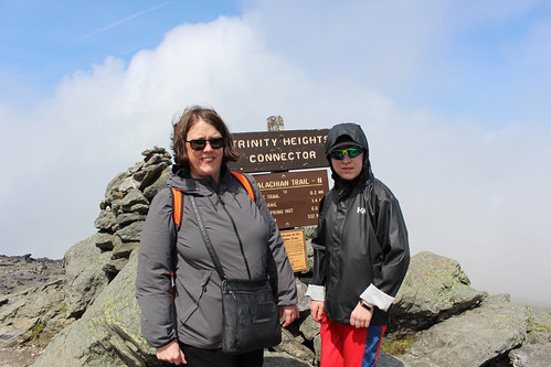
At the end of the ascent, you get to spend one hour on the summit (photos 62-111). The summit is 6288 feet, the highest in New England. It was very cloudy with the clouds moving quite quickly. It was somewhat cold, but not super busy, which surprised me until I reminded myself it WAS a Tuesday, not a weekend. I guess only the real tourists are out on Tuesdays. We posed for photos, mailed some postcards, and took lots of photos. We could even see the base of the Auto-Route (where the gift shop was) from the day before, once some of the clouds cleared. It was pretty wispy for most of our hour, but in the last 5-10 minutes, the sun was out a bit more.
We started our 45-minute descent, but as a digression, I was a bit confused by their model — the railcar on the way up was far from full, somewhere between perhaps 40-60%, depending on how you calculated “full”, and a couple of the other railcars went up empty with some others coming back down empty. They have side spurs so they could pull off to pass so it wasn’t that if one went, they all had to go. But they seemed to run all of the cars at once, regardless of the immediate demand, and it is one car per engine. Equally, they told us to come back down with the exact car we went up in…yet others joined our group without any sort of “reconciliation” process for them to know that the person was now on this car instead of the other one, and one group even seemed to leave some friends behind to catch the next one. In short, they appeared to run it like a railway with ticket takers, counting, check-ins for each “car”, and actual assigned times, but lots of people seemed to be using it more like a subway system, catching whichever train was available. They did mention that you COULD also do the train one-way — hike up and ride down or ride up and hike down — which could throw off their numbers sometimes. The one young narrator mentioned that there had been a really cold snap back in June when a whole bunch of hikers got caught by cold nasty weather near the top — so they cancelled their hiking plans to descend and all piled into the railcar. Which was already full, and so they ended up sitting / standing in the aisles. Which NONE of the other passengers were very happy about, apparently. It just seemed like a very strange business model — why send empty cars so often and why insist on matching tickets? I wondered if maybe it was a volume thing…if it was near capacity, everyone had to treat it like a train; if it was as light as it was our day, people could treat it like a subway.
Anyway, digression aside, it is an equally slow descent (45 minutes at 5 miles per hour). This is when we learned about the railcar not actually being attached to the engine, so if the engine suddenly had a problem, our car itself needed its own brakes and steering options, WITH a conductor (named Jacob!) who looked like he was 14 being responsible for our safety in the event of a runaway. It was not very comforting. 🙂 What WAS comforting for our return was that the benches in the railcar were convertible. They start off facing uphill, and then can be flipped so they face downhill. We had padding for the downhill portion, which was much more comfortable than the ascent, and we had no need to test their safety plans. We also learned some stories about past railway staff in history using the tracks like a railway luge which didn’t go over very well with the safety boards, which banned it and made it a criminal offence. And we learned something interesting for the weather even this year — they had more snow in JUNE than they did in February. Not sorry I missed that experience. From the photos, you can also see that as we descended, we went from almost non-existent vegetation (except growing on rocks) into small shrubs and then a bit of distance to get into actual full trees. The lichen at the top is very short and reflects a lot of light — hence it appears white from a distance, and hence the name White Mountains. (The descent and base are seen in photos 112-161).
We had a blast on the train and the summit. Hence struggling to curate the gallery below 150 photos. There was a lot to see!
We knew our final destination of the day was Bangor, Maine, and if you asked the GPS to find you a route, it would have sent you back North. So we went South, of course. We headed for North Conway, past the Mount Washington Resort (hotel) which is huge and iconic — and across the road from the Bretton Woods hotels that were the site of the meetings that created the World Bank and the IMF (and why they are called the Bretton Woods institutions). We cruised along until lunch, enjoying more of New Hampshire and the White Mountains, and then ate at a Dairy Queen before continuing on to North Conway. We crossed the border into Maine and enjoyed a leisurely drive through what looked like cottage-country with lots of lakes and rivers (photos 162-170 pre-Maine and 171-175 for early Maine).
The only real downside to the drive was the dang GPS. It kept giving us really weird routes…2 km down a road, and then a turn; another 1 km and then a turn back; then go straight for 2 km and I’d be back on the same highway. It took us on perhaps the “fastest” route but with no real sense of purpose. Some of the twists and turns looked longer than if we’d just taken the main route. I eventually had to call a halt to the twists and turns as I couldn’t enjoy the trip if, every five seconds, I had to check where we were. We instead pushed straight to the major interstate and headed North.
It was a long day at that point, after being up early and three hours on the Mountain, so we were focused on getting to Bangor where we had a hotel room for the night. We had been having this on-again, off-again conversation if we were trying to definitely see every state capital or not, and if any of the three of us cared enough to push for it as opposed to all three of us thinking the same thing i.e., “sure, why not, unless there was a reason not to at the time”. As we got closer to Augusta, we found a reason.
We could see a storm coming from a long way off. Very dark, very threatening skies. About 4 interchanges before Augusta, the storm hit. It was still daytime, so the roads were well-lit, but I had no real interest in finding my way around an unfamiliar state capital in the pouring rain to maybe see a building through the downpour. We skipped it and stayed on the highway. I had good traction and visibility; the driving was all fine, so I just kept going. I didn’t see many people pulling off, but the storm lasted a good 45 minutes of very hard pounding rain, lightning bolts in the distance, and lots of thunder. It stopped for about 30 minutes and then came back again for another 15-20 minutes. I saw there had been an accident on the other side; it looked like a bad wreck, but otherwise, no sign of anything. Just a strong storm (photos 176-181).
We arrived at the Comfort Inn at Bangor and found out that we should be considered “lucky” to have a room as tourists, as there was a big concert in town that night. Godsmack and Staind. Of course, I could obviously see the desire and why there would be such high demand (I have no idea who either band are or how that would fill every hotel in Bangor, but apparently the storm had closed a bunch of airports on the East Coast so some people were stranded too). Anyway, we checked in and settled for a little bit before heading out for dinner. I had mentioned Andrea’s excitement earlier at seeing an Olive Garden in Vermont? Well, we didn’t go there. But we did go to a functioning Pizza Hut. Jacob really likes Pizza Hut, but the one closest to us shut down as an in-person eatery; it’s just take-out now. So, we found the Pizza Hut and went for dinner with a whopping two other tables active. Admittedly we were a bit later than the Pizza Hut crowd would normally eat, closer to 8:00 p.m. than 5:00 p.m., but the waitress mentioned that lots of people coming in tell her the same thing about Pizza Huts in their hometowns all along the Eastern coast, down to Virginia and Florida. This is a trend running probably 15-20 years at this point, since their long-ago heyday, but we were happy to do it for the night.
Afterwards, Andrea wanted to go to Stephen King’s house. I’m pretty sure we didn’t have an invitation, but his address is publicly listed, sooooo off we went. It felt very stalkerish, particularly with no obvious security. Almost like a Stephen King novel. He didn’t appear to be home, or if he was, he was hiding from us. The house does have a very interesting gate though. The disturbing part for me? We weren’t the only ones there doing it. There was another car with 4 people out wandering the neighbourhood. I made Andrea go by herself to the gate, and take the pictures. It felt too skeezy to me (photos 182-187). If it had been Warren Murphy (long passed, alas), I would have been out there building a shrine.
We wound up the excursion, got almost lost in the dark going back to the hotel, as some roads just DO not lead to where you want them to go. And called it a night.
Overall, as I said earlier, it was a long day of driving with 384 km in total. We were total shutterbugs on the mountain, racking up 402 photos and videos for the day and I could only curate it down to about 187. It was fascinating going through some of the photos where all three of us took an almost identical photo of the same thing — Jacob with his iPhone, Andrea with her iPhone, and me with my DLSR (Canon T5i Rebel) — and yet on an almost random basis, one of us managed a composition that the other two didn’t. Jacob was at the window for the ascent and descent on the railcar, so he had the best views from the train. And some of them are spectacular. However, up on the summit, we did a few of a very similar view with perhaps only a slightly different angle, and one photo was stellar and the other two were just “ho hum”. Sometimes the angle, sometimes the composition. It’s really fun to sort through some of them and see the choices. And that it isn’t like, “all the best were the DSLR” or “Jacob got all the best shots”. The resulting gallery represents a true mix of photos from all three of us.


You could mention that our train conductors were Hannah and Jacob.